


-
Vendor:Hema
Flinders Ranges Atlas & Guide
This first edition of Hema’s Flinders Ranges Atlas & Guide features Hema’s distinctive and informative maps, all of which have been field checked by Hema’s Map Patrol to ensure the best possible accuracy with the latest mapping data. Written and researched by some of...- $49.95
- $49.95
- Unit price
- per
-
Vendor:Hema
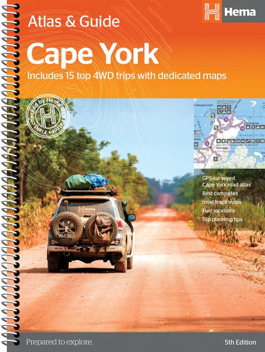
Cape York Atlas & Guide
Hema Maps’ Cape York Atlas & Guide helps you make the most of your visit to this remarkable part of Australia. With detailed coverage of The Tip, the coast from Cairns to Cooktown, Rinyirru (Lakefield) National Park, the Peninsula Developmental Road, Old Telegraph Track,...- $49.95
- $49.95
- Unit price
- per
-
Vendor:Hema
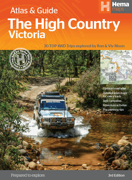
The Victorian High Country Atlas & Guide
The definitive guidebook for discovering the Victorian High Country, featuring the Top 30 4WD Trips written by Ron and Viv Moon, in combination with topographic atlas mapping for the region. This edition of Hema’s best-selling outdoor guidebook for discovering the Victorian High Country now...- $49.95
- $49.95
- Unit price
- per
-
Vendor:Hema
Caravan Parks 6
As the most comprehensive caravan and tourist park publication in Australia, Caravan Parks Australia-wide is a must-have travelling companion. Whether you are a caravanner, motor homer or a traveller looking for cabin-style accommodation, this guidebook contains all the information you need to find a place to stay. A...- $59.95
- $59.95
- Unit price
- per
-
Vendor:Hema
4WD + Camping Escapes South East Queensland - Atlas
This guide from Hema outlines the best four-wheel driving and camping locations in the picturesque South East Queensland featuring: Brisbane & Moreton Bay Islands Sunshine Coast Hinterland & South Burnett Cooloola Coast Main Range & South West Each regional section outlines the area’s 4WD Tracks...- $29.95
- $29.95
- Unit price
- per
-
Vendor:Hema
4WD Treks Close to Melbourne - Atlas
Fully updated and field checked by the Range Rover Club of Victoria, this fourth edition of 4WD Treks Close to Melbourne will take you on 20 of the best 4WD adventures within a couple of hours drive of the city.Whether you are looking for...- $49.99
- $49.99
- Unit price
- per
-
Vendor:Hema
4WD Adventures - Atlas
Discover Australia’s Top 100 4WD tracks using this guide as your ultimate off-road adventure tool. Each page features colourful, glossy imagery and detailed tracks personally mapped out and driven by the Hema Map Patrol and our team of experts, for the most up-to-date information...- $69.95
- $69.95
- Unit price
- per
-
Vendor:Hema
Camping Guide to Tasmania
The perfect guidebook to over 180 sites throughout Tasmania in more than 50 parks, forests and reserves. The newest edition contains 5 regional and 12 park and reserve maps. Over 180 campsites Full state-wide coverage Detailed information on campsite access and facilities Includes reserve, regional...- $34.99
- $34.99
- Unit price
- per
-
Vendor:Hema
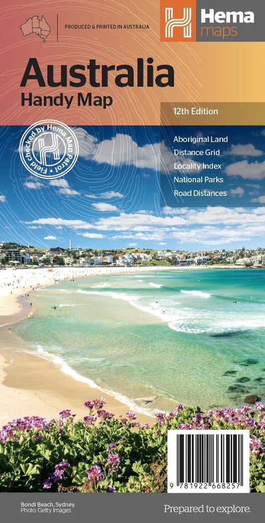
Australia Handy Map
The Australia Handy Map is a foldable, compact Australian map that is perfect as a journey planner or reference tool. It shows national parks and major road networks with distances for planning, along with major city CBD maps for Brisbane, Melbourne, Sydney, Canberra, Darwin, Adelaide, Perth and Hobart on the reverse side, as well as a...- $11.95
- $11.95
- Unit price
- per
-
Vendor:Hema
Yarra Valley - West Gippsland Adventure Map
Prepare for thrilling outdoor adventures with the Rooftop Maps Yarra Valley - West Gippsland Adventure Map. This double-sided map is tailor-made for motorbiking, bush camping, and four-wheel driving, making it your ultimate guide to exploring the natural wonders of the region. One side of...- $12.95
- $12.95
- Unit price
- per
-
Vendor:Hema
South Gippsland - Wilsons Promontory Map
A double-sided map that covers from Wonthaggi to east of Yarram, including Wilsons Promontory and Tarra-Bulga National Parks, Foster, Korumburra, Inverloch, Leongatha, Walkerville, Waratah Bay, Yanakie, Cape Liptrap, Port Albert, Fish Creek, Corner Inlet and Mirboo North on one side, and the other features...- $12.95
- $12.95
- Unit price
- per
-
Vendor:Hema
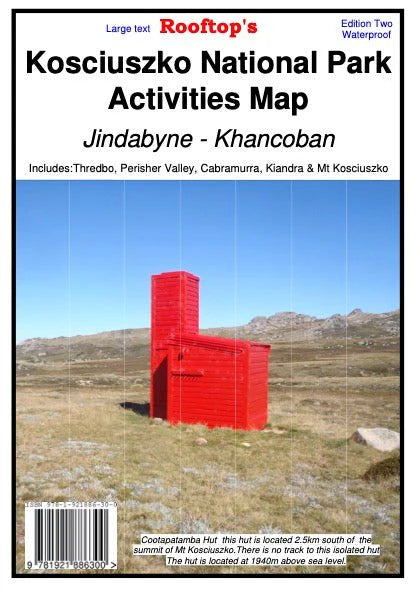
Kosciuszko National Park Forest Map
Kosciuszko National Park Activities Map is on durable waterproof paper, double sided and field checked. This map covers from Jindabyne to Khancoban at a 1:50,000 scale and includes Thredbo, Perisher Valley, Cabramurra, Kiandra and Mt Selwyn. Incredibly detailed which includes camping areas, national parks,...- $15.95
- $15.95
- Unit price
- per
-
Vendor:Hema
Jamieson - Licola Adventure Map
Embark on a remarkable journey through Victoria's wild landscapes with the Rooftop Maps Jamieson - Licola Adventure Map. Covering an extensive area from Aberfeldy to Wonnangatta, this map unveils the region's natural beauty, including notable destinations like Woods Point, Mount Skene, the Alpine National...- $12.95
- $12.95
- Unit price
- per
-
Vendor:Hema
Dargo - Wonnangatta Adventure Map
Set out on a thrilling 4WD adventure with the Rooftop Maps Dargo - Wonnangatta Adventure Map. This double-sided map is your passport to some of the most remarkable off-road terrain in Australia. One side guides you from the picturesque Licola to the majestic heights...- $12.95
- $12.95
- Unit price
- per
-
Vendor:Hema
Benalla - Mansfield - Strathbogie Ranges Map
A double-sided map; on one side is the Adventure Map side (1:100 000 no contours) and includes the popular camping areas along the Goulburn River around Murchison. It also now includes most of the Winton Wetlands Forest Activities. On the other side is the Forest...- $14.95
- $14.95
- Unit price
- per
-
Vendor:Hema
Victoria Handy Map
From the rolling High Country in the east to the expanses of the Wimmera region in the west; the rugged Shipwreck Coast in the south to the lazy Murray River that scribbles the northern border; Victoria is a road trip paradise. Hema's Handy Map...- $11.95
- $11.95
- Unit price
- per
-
Vendor:Hema
Mansfield - Mt Howitt Adventure Map
Map coverage is from Mansfield and Lake Cobbler in the north to Jamieson, Kevington and Mount Sunday in the south. It includes Craig's Hut, Sheepyard Flat, Mount Buller, Mount Stirling, Howqua Hills, Jamieson River, Mansfield State Forest, Alpine National Park (part), King Billy, and...- $12.95
- $12.95
- Unit price
- per
-
Vendor:Hema
Tasmania State Map
The fourth edition of Hema’s Tasmania State Map features Hema’s distinctive and informative maps fully, all of which have been field checked by Hema’s Map Patrol to ensure the best possible accuracy with the latest mapping data. A fully indexed state map of Tasmania...- $15.95
- $15.95
- Unit price
- per
-
Vendor:Hema
South Australia State Map
A map of South Australia for touring throughout the state, marked with camping and rest areas, 24-hour fuel and points of interest. On the reverse are CBD, surrounding region and through road maps of Adelaide in addition to maps of Flinders Ranges National Park...- $15.95
- $15.95
- Unit price
- per
-
Vendor:Hema
The Kimberley Map
A regional map of the Kimberley that features the iconic Gibb River Road. On the reverse are inset maps for Purnululu National Park, the Dampier Peninsula and the Parry Creek area. Detailed trip coverage and drive detail for the Gibb River Road is featured...- $15.95
- $15.95
- Unit price
- per