


-
Vendor:Hema
Gippsland Lakes - Ninety Mile Beach Map
A map that covers from Lakes Entrance to Heyfield, including Bairnsdale, Loch Sport, Maffra, Metung, Paynesville, Sale, Seaspray, Golden Beach, The Lakes National Park, Mullundung Forest and Holey Plains SP.- $14.95
- $14.95
- Unit price
- per
-
Vendor:Hema
Jamieson - Licola Adventure Map
Embark on a remarkable journey through Victoria's wild landscapes with the Rooftop Maps Jamieson - Licola Adventure Map. Covering an extensive area from Aberfeldy to Wonnangatta, this map unveils the region's natural beauty, including notable destinations like Woods Point, Mount Skene, the Alpine National...- $12.95
- $12.95
- Unit price
- per
-
Vendor:Hema
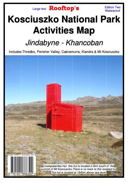
Kosciuszko National Park Forest Map
Kosciuszko National Park Activities Map is on durable waterproof paper, double sided and field checked. This map covers from Jindabyne to Khancoban at a 1:50,000 scale and includes Thredbo, Perisher Valley, Cabramurra, Kiandra and Mt Selwyn. Incredibly detailed which includes camping areas, national parks,...- $15.95
- $15.95
- Unit price
- per
-
Vendor:Hema
Mansfield - Mt Howitt Adventure Map
Map coverage is from Mansfield and Lake Cobbler in the north to Jamieson, Kevington and Mount Sunday in the south. It includes Craig's Hut, Sheepyard Flat, Mount Buller, Mount Stirling, Howqua Hills, Jamieson River, Mansfield State Forest, Alpine National Park (part), King Billy, and...- $12.95
- $12.95
- Unit price
- per
-
Vendor:Hema
Marysville - Lake Eildon Adventure Map
Discover the captivating landscapes of Victoria’s High Country with the Rooftop Maps ‘Marysville - Lake Eildon Adventure Map’. This double-sided map is your gateway to a world of outdoor exploration, covering Lake Eildon, the Yarra Ranges National Parks, and an array of remarkable destinations...- $14.95
- $14.95
- Unit price
- per
-
Vendor:Hema
Mt Disappointment - Kinglake Ranges Map
A double-sided map that covers the region just north of Melbourne, including Mt Disappointment and Mt Robertson State Forests, Kinglake National Park, Whittlesea, Kinglake, Flowerdale and Strath Creek.- $12.95
- $12.95
- Unit price
- per
-
Vendor:Hema
Northern Territory Handy Map
A map of the Northern Territory that features camping and rest areas, 24hour fuel and points of interest. On the reverse are through road maps of Darwin and Alice Springs, a map of the greater Darwin region. For trip planning there is a national...- $11.95
- $11.95
- Unit price
- per
-
Vendor:Hema
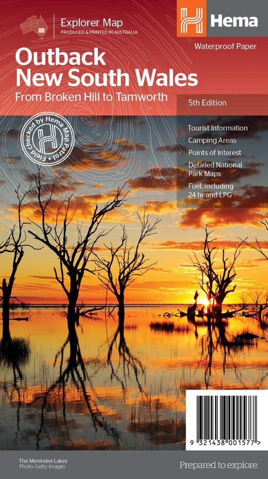
Outback New South Wales Map
Outback New South Wales Map (5th edition) A regional map of outback NSW (1:1,100,000) that ranges from Tamworth in the east to Broken Hill in the west, as well as from Wagga Wagga in the south to past the Queensland border in the north....- $15.95
- $15.95
- Unit price
- per
-
Vendor:Hema
Pilbara & Coral Coast Map
This regional waterproof map of the Pilbara and Coral Coast is ideal for discovering the northern reaches of Western Australia. The main map covers the diverse marine attractions around Shark Bay, François Peron National Park and the Ningaloo Reef. It also stretches to the...- $15.95
- $15.95
- Unit price
- per
-
Vendor:Hema
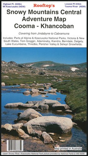
Snowy Mountains Central, Cooma, Khancoban Map
A double-sided map that covers from Jindabyne to Cabramurra, including parts of the Alpine and Kosciuszko National Parks, Victoria and New South Wales, Tom Groggin, Adaminaby, Kiandra, Berridale, Dalgety, Lake Eucumbene, Thredbo, Perisher Valley and Selwyn Snowfields on one side, and the other being...- $14.95
- $14.95
- Unit price
- per
-
Vendor:Hema
South Australia Handy Map
A map of South Australia that displays camping areas, caravan parks, points of interest, rest areas and fuel outlets and is geared for those touring throughout the state. Accompanying the map is an index of towns and localities, as well as a distance chart....- $11.95
- $11.95
- Unit price
- per
-
Vendor:Hema
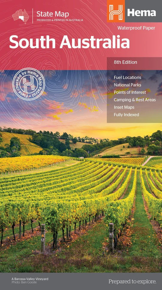
South Australia State Map
A map of South Australia for touring throughout the state, marked with camping and rest areas, 24-hour fuel and points of interest. On the reverse are CBD, surrounding region and through road maps of Adelaide in addition to maps of Flinders Ranges National Park...- $15.95
- $15.95
- Unit price
- per
-
Vendor:Hema
South Gippsland - Wilsons Promontory Map
A double-sided map that covers from Wonthaggi to east of Yarram, including Wilsons Promontory and Tarra-Bulga National Parks, Foster, Korumburra, Inverloch, Leongatha, Walkerville, Waratah Bay, Yanakie, Cape Liptrap, Port Albert, Fish Creek, Corner Inlet and Mirboo North on one side, and the other features...- $12.95
- $12.95
- Unit price
- per
-
Vendor:Hema
Tallarook Forest Activities Map
Tallarook is set on the northern slopes of the Great Dividing Range in Victoria. Tallarook State forest comprises 5,100 ha of mixed species Eucalypt forest. Tallarook State forest provides excellent opportunities for recreational four-wheel-driving, camping, bushwalking, mountain bike riding, horse riding and trail bike...- $6.00
- $6.00
- Unit price
- per
-
Vendor:Hema
Tasmania Handy Map
A compact map of Tasmania for touring throughout the state with a distance grid and index for planning and reference. Marked on the mapping are highways, major and minor roads, camping and rest areas, 24-hour fuel, information centres, picnic areas, caravan parks, and lookouts....- $11.95
- $11.95
- Unit price
- per
-
Vendor:Hema
Tasmania State Map
The fourth edition of Hema’s Tasmania State Map features Hema’s distinctive and informative maps fully, all of which have been field checked by Hema’s Map Patrol to ensure the best possible accuracy with the latest mapping data. A fully indexed state map of Tasmania...- $15.95
- $15.95
- Unit price
- per
-
Vendor:Hema
The Kimberley Map
A regional map of the Kimberley that features the iconic Gibb River Road. On the reverse are inset maps for Purnululu National Park, the Dampier Peninsula and the Parry Creek area. Detailed trip coverage and drive detail for the Gibb River Road is featured...- $15.95
- $15.95
- Unit price
- per
-
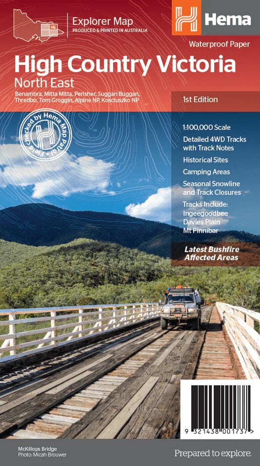
Vendor:Hema
The Victorian High Country - North Eastern Map
This map is part of Hema's new Victorian High Country Map Series and covers the Northern Borderlands Area. It overlooks the ranges that border Victoria and New South Wales from Omeo to Jindabyne, including such destinations as Benabra, Perisher, Tom Groggin, Thredbo, and Kosciuszko...- $15.95
- $15.95
- Unit price
- per
-
Vendor:Hema
The Victorian High Country - North Western Map
This map is part of Hema's new Victorian High Country Map Series and covers the North-Western Alps Area. It overlooks Hotham, Wangaratta and surrounds including Bright, Bogong, Mount Buffalo, Dinner Plain and Falls Creek along with hundreds of 4WD tracks set among spectacular alpine...- $15.95
- $15.95
- Unit price
- per
-
Vendor:Hema
The Victorian High Country - South Eastern Map
This map is part of Hema's new Victorian High Country Map Series and covers the Southern Lowlands and Lakes Areas. It overlooks Gippsland, Howqua, Jamieson, Licola, Maffra, Lawson, Walhalla, Woods Point and Alpine, Snowy River and Mitchell National Parks. Printed on durable waterproof paper,...- $15.95
- $15.95
- Unit price
- per